Stan Amster Photography – Scenic and Commercial Photography in Northern New England.

Generic selectors
Exact matches only
Search in title
Search in content
Post Type Selectors
post
page
ngg_pictures

Histroic

Middlebury Falls in Middlebury Vermont

Middlebury-Falls-Middlebury-VT-8-30-3019-7-Edit-Edit
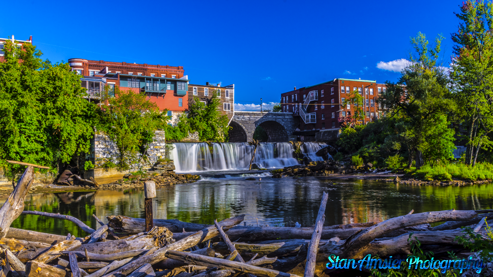
Middlebury Falls is an impressively broad waterfall along Otter Creek located in downtown Middlebury Vermont. The falls plunge only 18 feet over an undercut shelf, but stretch 170 feet across and during periods of higher flow the river will overwhelm the entire cliff face, while during the summer and early autumn months it may segment into two or three distinct channels. Remnants of a small millrace on the right side of the falls are also visible, with a small portion of the creek being diverted through, though not nearly enough to impact the volume of water actually flowing over the falls.


Despite being an urban waterfall, found right in the center of the town of Middlebury, the development around the falls doesn’t detract from the scene quite as much as one might otherwise assume at first glance, and the city has done a great job at both embracing the falls and providing multiple public open spaces with views of the falls. A long metal footbridge spans Otter Creek downstream from the falls and provides interesting views through a grove of trees adjacent to the old mill race, and a nice park with ample open space on the north side of the stream allows for airy, unobstructed views of the whole falls.

Middlebury Falls in Middlebury Vermont Read More »

Sunset Lake Floating Bridge (AKA:The Brookfield Floating Bridge) in Brookfield Vermont

Brookfield-Vermont-114-Edit-Edit-Edit
The first bridge on this site was erected in 1820. It was built this way because the lake is too deep for traditional pilings.
The seventh bridge was closed to traffic and torn down in 2008 for replacement due to failure of its flotation system, which was based on foam-filled barrels.
The current bridge, the eighth at this location, is supported by fiber-reinforced polymer pontoons.

It is kinda weird to drive over if you are not use to it.

Sunset Lake Floating Bridge (AKA:The Brookfield Floating Bridge) in Brookfield Vermont Read More »

Picture perfect day in Peacham Vermont

Vermont-8-16-2014-13-2
I thought I would get out on a picture perfect day and head over to Peacham and a few other places in the NEK. The weather was perfect.

In 1763, Governor Benning Wentworth of New Hampshire gave a charter for the region to a group of proprietors, and the town was given the name Peacham (the etymology of the name is unclear). The original proprietors were speculators who surveyed the town, laid a few rudimentary roads, and divided it into lots, though the territory remained unsettled for some time.


In 1775, settlers, primarily from Connecticut and Massachusetts, bought the lots and built homes, developing the land for agriculture. The original settlers survived almost entirely through subsistence farming despite the long winters, hilly terrain, and rocky soil. Nine years later, records show a population of approximately 200 people. The first recorded town meeting took place in 1784, and selectmen were duly elected to govern the affairs of the town. Peacham was early on presented with a choice of having either the county courthouse or the county school, and the residents voted for the school. In 1795 the Caledonia County Grammar School received its charter, and the first school was established in a log structure on the Bayley Hazen Road, halfway between Peacham Corner and South Peacham.


In 1799, a library was established, which traveled from store to store. A congregational church was founded in 1794 – the first pastor, Leonard Worcester, was well known for his fiery sermons. His son Samuel went on to be an important missionary to the Cherokee people, creating the first typeface for the Cherokee alphabet and gaining lasting fame as the plaintiff in the supreme court case Worcester v. Georgia.

Picture perfect day in Peacham Vermont Read More »

Pemaquid Point Lighthouse in Bristol Maine

Pemaquid-Light-10-8-2010-028
Without a doubt, this is my favorite lighthouse in New England.

The lighthouse was commissioned in 1827 by President John Quincy Adams and built that year. Because of poor workmanship (salt water was used in the mortar mix), the lighthouse began to crumble and was replaced in 1835. The second contract for the construction stipulated that only fresh water be used. Keeper Isaac Dunham oversaw the construction and wrote in a letter to the US Lighthouse Establishment that the agreement was upheld and the work went well.

The original light was an Argand-Lewis parabolic reflector, lit with candles and with a visibility of 2 miles (3.2 km). Augustin Fresnel invented a superior way of focusing light in the early 1850s and most lighthouses in the US were converted to the Fresnel Lens, with Pemaquid Point receiving a fourth order Fresnel

Pemaquid Point Lighthouse in Bristol Maine Read More »

Pemaquid Point Lighthouse in in Bristol Maine.

Pemaquid-Light-5-24-2010-024-Edit
Pemaquid Point Lighthouse. Commissioned by John Quincy Adams in 1827, this Maine lighthouse has the Fisherman’s Museum on the first floor in the Keepers House, and there is the possibility of renting the apartment on the second floor. The Pemaquid Point Lighthouse Park is located at the entrance to Muscongus Bay and Johns Bay, in the town of Bristol. The Town of Bristol purchased the park property from the Coast Guard in 1940 with the exception of the light tower. Pemaquid Point Lighthouse Park is managed by the Bristol Parks Commission.

Without a doubt, this is my favorite lighthouse in all of New England.

Pemaquid Point Lighthouse in in Bristol Maine. Read More »